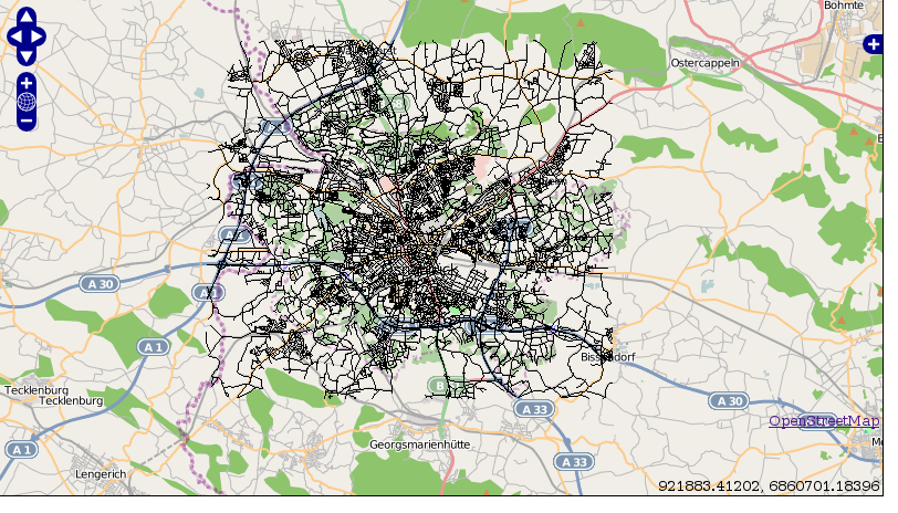
Explanation of the OpenLayers-Code step 2
You might want to test if you routing-data are located correctly above the OpenLayers-OSM-Application, just take away the // at
var wms= new OpenLayers.Layer.WMS.Untiled( "strassen",

     "http://localhost/cgi-bin/mapserv?map=/your_path/routing.map",

        {layers: 'streets',transparent:true, format: 'png'});


     wms.isBaseLayer= false;
and write also:
map.addLayers([mapnik, start, stop,result,wms]);
In the mapfile you should comment out
#TEXT ([gid],[source],[target])
and you will get a screen like:

[[Great!!!!!]], so you know that the routing-data are on the right position in the map!! If you want you can turn off the WMS.
Some more explanations of the OpenLayers-Code:
var options = {
     projection: new OpenLayers.Projection("EPSG:900913"),
     displayProjection: new OpenLayers.Projection("EPSG:4326"),
     units: "m",
     numZoomLevels: 22,
     maxResolution: 156543.0339,
     maxExtent: new OpenLayers.Bounds(-20037508, -20037508,
                                      20037508, 20037508.34)
 };

 map = new OpenLayers.Map('map', options);
 map.addControl(new OpenLayers.Control.LayerSwitcher());
Projection and extend (of the Google-Mercator.projection) are set. Also a map-object is created and a Layerswitcher integrated. Coordinates are shown in WGS84 ( displayProjection: new OpenLayers.Projection(“EPSG:4326”), ).
function osm_getTileURL(bounds) {

     var res = this.map.getResolution();

     var x = Math.round((bounds.left - this.maxExtent.left) / (res * this.tileSize.w));

     var y = Math.round((this.maxExtent.top - bounds.top) / (res * this.tileSize.h));

     var z = this.map.getZoom();

     var limit = Math.pow(2, z);


     if (y < 0 || y >= limit) {

         return OpenLayers.Util.getImagesLocation() + "404.png";

     } else {

         x = ((x % limit) + limit) % limit;

         return this.url + z + "/" + x + "/" + y + "." + this.type;

     }

 }
With that function you get OSM-Tiles for the layer mapnik:
        // create OSM layer

var mapnik = new OpenLayers.Layer.TMS(

    "OpenStreetMap (Mapnik)",

      "http://a.tile.openstreetmap.org/",

    {

        type: 'png', getURL: osm_getTileURL,

        displayOutsideMaxExtent: true,

        attribution: '<a href="http://www.openstreetmap.org/">OpenStreetMap</a>'

    }

);
And very important!
Very important is the following code-snippet:
    if (startPoint && stopPoint) {

            OpenLayers.loadURL("routing.php?startpoint="+startPoint.geometry.x+" "+startPoint.geometry.y+"&finalpoint="+stopPoint.geometry.x+" "+stopPoint.geometry.y+"&method=SPD&srid=900913",
                               null,
                               null,
                               displayRoute,
                               null);

        }
    }

function displayRoute(response) {
    if (response && response.responseXML) {

        // erase the previous results
        result.removeFeatures(result.features);

    function parseWKT(wkt) {
   parser = new OpenLayers.Format.WKT();
       var geometry = parser.read(wkt)
        var features = parser.read(wkt);
        var bounds;
        if(features) {

            if(features.constructor != Array) {
                features = [features];
            }
            for(var i=0; i<features.length; ++i) {
                if (!bounds) {
                    bounds = features[i].geometry.getBounds();
                } else {
                    bounds.extend(features[i].geometry.getBounds());
                }

            }
         result.addFeatures(features);

        } else {
        alert ("wrong");
            element.value = 'Bad WKT';
        }
    }
            // parse the features
            var edges = response.responseXML.getElementsByTagName('edge');
            var features = [];
            for (var i = 0; i < edges.length; i++) {
                var g = parseWKT(edges[i].getElementsByTagName('wkt')[0].textContent);
                features.push(new OpenLayers.Feature.Vector(g));
            }
            result.addFeatures(features);
        }
If start- and endpoint are set and you click on “calculate route” via Ajax an URL is called with the coordinates of start and end-points
(OpenLayers.loadURL(“routing.php?startpoint=”+startPoint.geometry.x+” “+startPoint.geometry.y+”&finalpoint=”+stopPoint.geometry.x+” )
routing.php creates the geometry of the routing-ways (We will come to routing.php in the next step).
If these ways are correctly given back to our OpenLayers-script “parseWKT” is called. This parses the given “Well Known text-geodata” from routing.php.
In
for (var i = 0; i < edges.length; i++) {
             var g = parseWKT(edges[i].getElementsByTagName('wkt')[0].textContent);
             features.push(new OpenLayers.Feature.Vector(g));
         }
         result.addFeatures(features);
the geometry is parsed and set as a new Feature to the layer result.