Killing some bugs (wrong path calculation)
At this point you will find out that some routes are not correct.
Please use the following extent in Openlayers
map.zoomToExtent(new OpenLayers.Bounds(894000,
                                            6850300,
                                            894500,
                                            6850600));
For example you get a wrong path like:
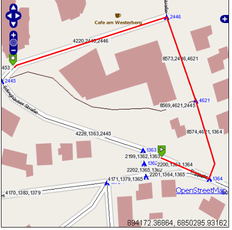
What you see in here in blue is the number of the vertices.
The three figures (black on grey) are the gid,the source-id and the target-id of a Multilinestring.
By looking at the screenshot obviously the shortest path is via “Edinghäuser Straße”, why is the route so, let`s say “weird”?
The start point is at the Multilinestring with the gid 2200, the source-id is the number 1363. The end point is at the Multilinestring with the gid 4220, the target_id is 2446.
Iy you the vertives 1363 and 2446 you understand why it goes that path, remember: The function for this is:
SELECT gid, the_geom
     FROM dijkstra_sp_delta(
         '".TABLE."',
         ".$startEdge['source'].",
         ".$endEdge['target'].",
         3000
One solution is to do the calculation “twice”, one as seen, and one more the other way round
SELECT gid, the_geom
     FROM dijkstra_sp_delta(
         '".TABLE."',
         ".$endEdge['source'].",
         ".$startEdge['target'].",
         3000
What will calculate from node 2445 on the Multilinestring 4220 to 1364 on Multiline 2200.